
Chicago Heights Address History Sources
The source to use depends on the year. Recent Chicago Heights previous residents research begins with the current PIN and Clerk recording index. Earlier households appear in scattered directory runs, telephone books, census schedules, and newspapers. Sanborn maps show the building and street, not the people. Permits and assessment snapshots date physical changes but do not create a continuous occupant list.
| Source | Years It Covers | Where Held | What It Shows |
|---|---|---|---|
| Cook County deed index | Online guidance says 1985-present; live index through 08-06-2026 | Clerk Recordings portal and counter | Instrument type, dates, PIN, legal description, and indexed parties |
| Chicago Heights directories | 1905-06, 1908-09, 1916, 1923-27, 1937, 1941 | Public Library History Room | Historical names and addresses, with gaps |
| Reverse directories and phone books | 1980s-90s reverse runs; listed phone-book years from 1913 onward | Chicago Heights Public Library | Address-to-name leads for a stated year |
| Federal census | Through 1950 generally public under the 72-year rule | Census, archives, and SSGHS | Household composition on the enumeration date |
| Sanborn maps | 1897, 1911, and 1950 online; 1911-56 reported locally | Library of Congress and library | Street, lot, structure, and use, not occupants |
| Permits and code records | Current portal categories; beginning year unstated | Chicago Heights BS&A, Code Enforcement, FOIA | Dated work, inspections, address, and record number |
Start online for a post-1985 transfer, then move to the Clerk counter for earlier tract or deed books. For a twentieth-century occupant, call or use Ask a Librarian before traveling because the reported local directory years are not continuous. SSGHS, the Illinois State Archives or IRAD, Cook County Archives remote reference, and Library of Congress scans extend the fallback chain.
Anchor Chicago Heights History by PIN
A modern street number is only a starting point. Search the Cook County Assessor or CookViewer, then save the 14-digit PIN and the legal-description clues. A PIN identifies the assessed parcel. The legal description names the land through a subdivision, lot and block, or section, township, and range. Both survive many street-label changes better than a typed address.
The inspected Chicago Heights sample shows why source dates matter. Its Assessor card and CookViewer REST snapshot agreed on the PIN and address but differed slightly in land square feet and building age. Do not force those values to match. Cite the portal, field, and date used.
The current Chicago Heights sample property card illustrates the parcel fields.
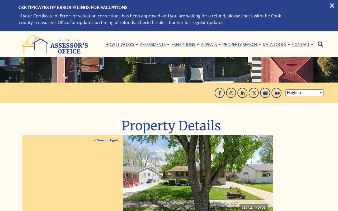
The card can anchor a backward trail, but its Property Location warning means it cannot prove who lived there.
Chicago Heights Deeds After 1985
The Cook County Clerk Recordings Search is a free index with paid images and copies. The inspected screen displayed documents indexed through August 6, 2026. Official guidance says online real-estate records date from 1985, although the live search screen does not state a start year. A blank result is not proof that no earlier transaction exists.
The former Recorder of Deeds functions moved to the Cook County Clerk on December 7, 2020. Older references may still say “Recorder,” but current requests go through Clerk Recordings. Earlier tract books and deed books should be verified at the downtown counter. Annexations, some plats and easements, condominium declarations, and several other document groups may also require an office copy rather than online purchase.
The recording index screen shows the address, PIN, and full-search routes.
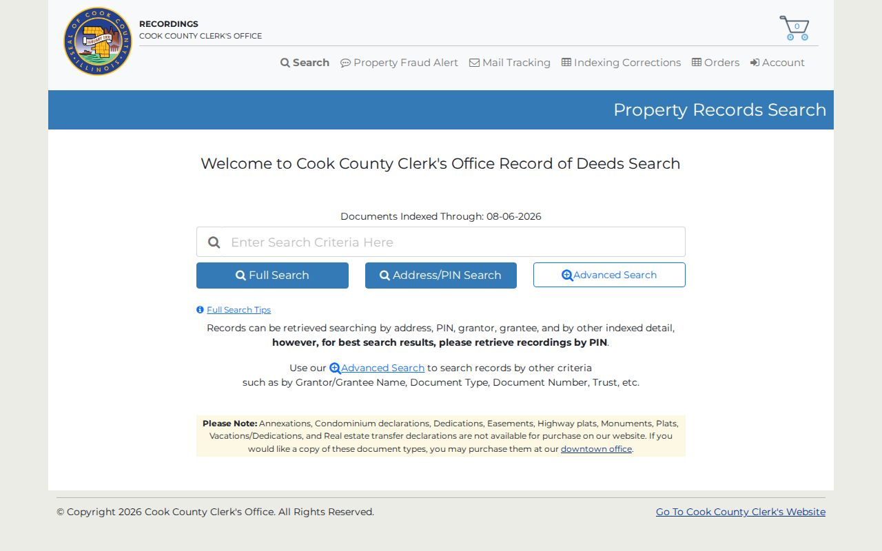
This is the online doorway to the deed chain, while the counter remains essential for older or counter-only material.
Note: Verify the live indexed-through date before reporting that a recent Chicago Heights instrument should appear online.
Trace Cook County Owners Backward
A chain of title is the linked sequence of recorded interests in the same land. To trace previous residents responsibly, keep that ownership chain separate from the occupant trail. A grantor transfers an interest, while a grantee receives it. The legal description confirms that two instruments concern the same parcel even when the street address changes.
- Find the current PIN through the Assessor or CookViewer and record the legal description.
- Search the PIN in Clerk Recordings and identify the latest true transfer instrument. Do not mistake a mortgage, release, or lien for a deed.
- Read the indexed parties or lawful copy. Search the seller as an earlier grantee, narrowing with dates and the legal description.
- Repeat the move backward. Watch for a parcel split, condominium unit, trustee’s deed, or predecessor legal description.
- When the online trail ends, request the tract or deed book at Clerk Recordings or seek archive reference help.
- Grantor and grantee
- The party giving an interest and the party receiving it.
- Chain of title
- The linked sequence of recorded transfers or interests affecting the same land.
- Legal description
- The formal land identifier used in recorded instruments, often stronger than an old street address.
The advanced grantor and grantee form supplies name, role, document type, date, and legal-description controls.
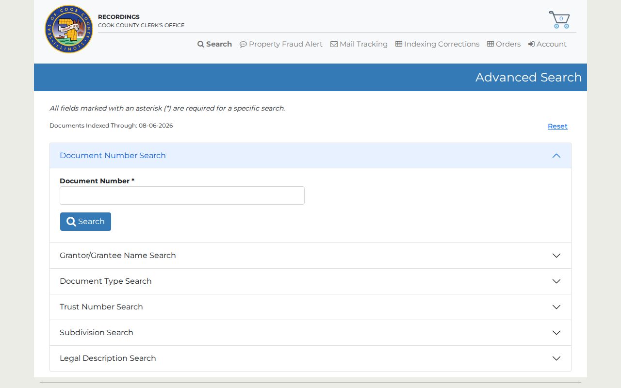
Those filters let the researcher test each link rather than joining same-name parties by assumption.
Read Chicago Heights Recording Results
A Clerk PIN result displays document number, recorded date, executed date, and document type, with controls to view or buy documents. The inspected sample returned 23 indexed instruments. That number describes the sample parcel only. It is useful because it shows how releases, mortgages, and payment records can sit between deeds and should not be counted as new owners.
The sample PIN result demonstrates the visible columns.
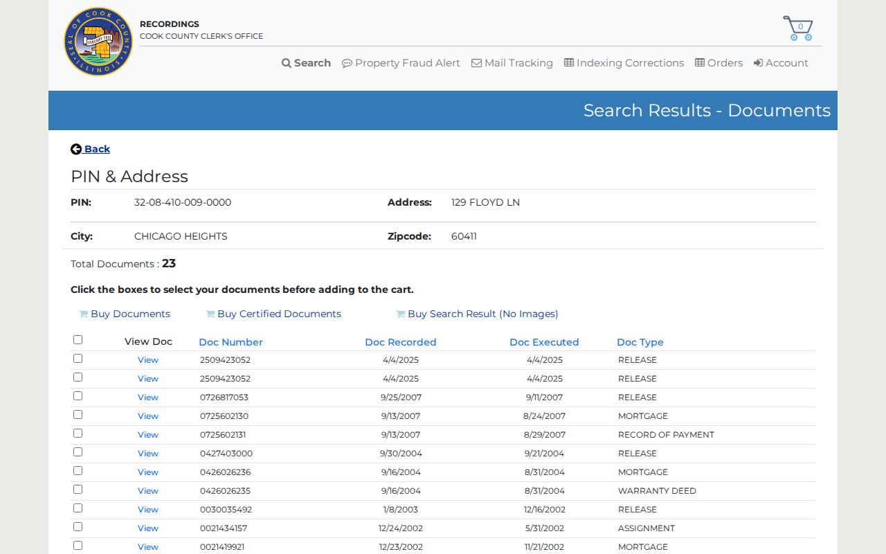
Open the relevant instrument or order a copy to confirm parties and land. The result list alone does not establish occupancy or the full meaning of a filing.
Chicago Heights House History Network
No standalone official Chicago Heights house-history guide or open digitized city-directory scan was located. The documented route is a three-part network: the Chicago Heights Public Library, the South Suburban Genealogical & Historical Society, and the Historic Preservation Advisory Committee. The committee states that Chicago Heights has no separate historical society, so these institutions divide the work.
The library History Room, catalog, microfilm, and Ask a Librarian service cover local maps, directories, phone books, the Chicago Heights Star and Signal, and historical files. SSGHS adds regional directories, census resources through 1950, cemetery and naturalization indexes, local files, yearbooks, church histories, and maps. Its public page currently says the library is closed until further notice because of storms, so call or email before travel.
Cook County Archives is also closed to public visits and offers remote reference. For municipal permit or map material that is not posted, use Chicago Heights Code Enforcement, the City Engineer, or a focused city FOIA request. These access paths are part of the record trail, not secondary afterthoughts.
Map Old Chicago Heights Buildings
Library of Congress Sanborn volumes include Chicago Heights in 1897, 1911, and 1950. The local holdings guide also reports paper or microfilm maps from 1911 through 1956. Compare the block, lot shape, building footprint, use, and street label across map years.
A Sanborn sheet never supplies a resident’s name. Pair it with a directory from the closest available year and then with a deed or census schedule. This is especially important in Chicago Heights because no official street-renumbering or renaming table was found. Maps, legal descriptions, ward maps, newspaper notices, and the PIN must bridge any suspected change.
Note: Never invent an earlier house number when the map and directory do not support the link.
Confirm Chicago Heights Past Households
Ownership is only half of a house history. A reverse directory can turn an address into a name for one publication year. The alphabetic city directory may show a spouse notation, occupation, telephone number, or another address. The Chicago Heights city directory page covers those collections and their gaps in full.
- Choose the closest available reverse or city directory year and transcribe the entry exactly, including initials and abbreviations.
- Compare the same address in the next available directory run. Record any move notation or street-label change.
- Pair the directory with the nearest public federal census schedule through 1950. Note the enumeration date and geography.
- Test the name and address against a deed, newspaper notice, permit, or lawful vital or probate source.
The Chicago Heights Star microfilm runs from 1906 to current in the holdings guide, while Signal is listed for 1911 through 1913. An obituary, marriage notice, advertisement, or estate notice can close a historical trail, but no official item-level local obituary index was found. Probate files must be requested through the court when the case is public, and vital-record eligibility rules still apply.
Lawful use. Chicago Heights previous residents research supports house history, genealogy, and estate work. Do not use a historical lead to track, harass, intimidate, or harm a living person.
A dated source may be accurate for its own time and still be wrong today. Keep past residents, recorded owners, and present occupants as separate conclusions.